Google Earth
From UtahRadio
(Difference between revisions)
RyanSimpkins (Talk | contribs) (New page: Future details regarding Salt Lake Co Google Earth maps.) |
RyanSimpkins (Talk | contribs) |
||
| Line 1: | Line 1: | ||
| − | + | Several members have put together a Google Earth layer for fire and UHP control regions for Salt Lake County. To use this map, follow these instructions: | |
| + | |||
| + | #Download and install [http://earth.google.com/ Google Earth]. | ||
| + | #Download this file: [http://utahradio.org/mediawiki/files/SLCoEmergencyServices.kml SLCoEmergencyServices.kml] | ||
| + | #Double click on the file, this should open Google Earth and add the layer in to your temporary places (on the left, under "Places"). | ||
| + | #Right click on "Salt Lake County - Emergency Services" and choose "Save to My Places" | ||
| + | |||
| + | The file will automatically be re-downloaded every 5 minutes to ensure you always get fresh information. If you would like to contribute to the file, please contact [http://www.radioreference.com/forums/member.php?u=58093 Utah_Viper] for access information. | ||
| + | |||
| + | [[Image:GoogleEarthScreencap.jpg]] | ||
| + | |||
| + | [[Category:Scanning]] | ||
| + | [[Category:Salt Lake County]] | ||
Revision as of 15:46, 1 January 2009
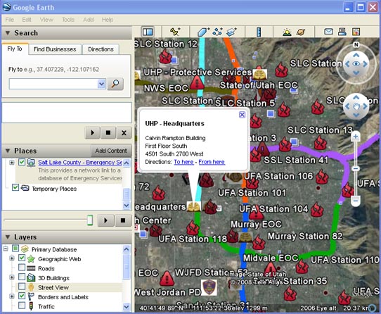
Several members have put together a Google Earth layer for fire and UHP control regions for Salt Lake County. To use this map, follow these instructions:
- Download and install Google Earth.
- Download this file: SLCoEmergencyServices.kml
- Double click on the file, this should open Google Earth and add the layer in to your temporary places (on the left, under "Places").
- Right click on "Salt Lake County - Emergency Services" and choose "Save to My Places"
The file will automatically be re-downloaded every 5 minutes to ensure you always get fresh information. If you would like to contribute to the file, please contact Utah_Viper for access information.
