Google Earth
RyanSimpkins (Talk | contribs) m |
|||
| Line 1: | Line 1: | ||
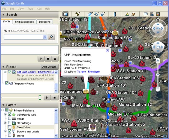
Several members have put together a Google Earth layer for various radio related points of interest in the state. Currently it only contains data for Salt Lake County emergency services. This map is a ongoing project. The goal is to eventually provide a multi-layered overlay of all emergency services related sites, equipment, apparatus, photos, amateur repeater locations, police departments, member listening locations, and hospitals. It will result in a simple to use multi-layered format so you can switch on or off what you do or do not want to see. To use this map, follow these instructions: | Several members have put together a Google Earth layer for various radio related points of interest in the state. Currently it only contains data for Salt Lake County emergency services. This map is a ongoing project. The goal is to eventually provide a multi-layered overlay of all emergency services related sites, equipment, apparatus, photos, amateur repeater locations, police departments, member listening locations, and hospitals. It will result in a simple to use multi-layered format so you can switch on or off what you do or do not want to see. To use this map, follow these instructions: | ||
| − | + | <br><br> | |
| + | If you wish to view in your Browser with Google Maps: <br> | ||
| + | [http://maps.google.com/maps?f=q&source=s_q&hl=en&geocode=&q=http:%2F%2Futahradio.org%2Fmediawiki%2Ffiles%2FUtahRadio.kml&ie=UTF8&ll=40.507535,-111.97403&spn=0.859319,1.411743&z=10 Utah Scanning Google Map] <br><br> | ||
| + | If You have Google Earth:<br> | ||
#Download and install [http://earth.google.com/ Google Earth]. | #Download and install [http://earth.google.com/ Google Earth]. | ||
#Download this file: [http://utahradio.org/mediawiki/files/UtahRadio.kml UtahRadio.kml] | #Download this file: [http://utahradio.org/mediawiki/files/UtahRadio.kml UtahRadio.kml] | ||
Latest revision as of 15:08, 9 February 2009
Several members have put together a Google Earth layer for various radio related points of interest in the state. Currently it only contains data for Salt Lake County emergency services. This map is a ongoing project. The goal is to eventually provide a multi-layered overlay of all emergency services related sites, equipment, apparatus, photos, amateur repeater locations, police departments, member listening locations, and hospitals. It will result in a simple to use multi-layered format so you can switch on or off what you do or do not want to see. To use this map, follow these instructions:
If you wish to view in your Browser with Google Maps:
Utah Scanning Google Map
If You have Google Earth:
- Download and install Google Earth.
- Download this file: UtahRadio.kml
- Open UtahRadio.kml, this should open Google Earth and add the layer.
- It will appear in to your temporary places (on the left, under "Places").
- Right click on "Salt Lake County - Emergency Services" and choose "Save to My Places." Skipping this step will cause the layer to disappear upon exit.
The file will automatically be re-downloaded every 5 minutes to ensure you always get fresh information. If you would like to contribute to the file, please contact Utah_Viper for access information.
